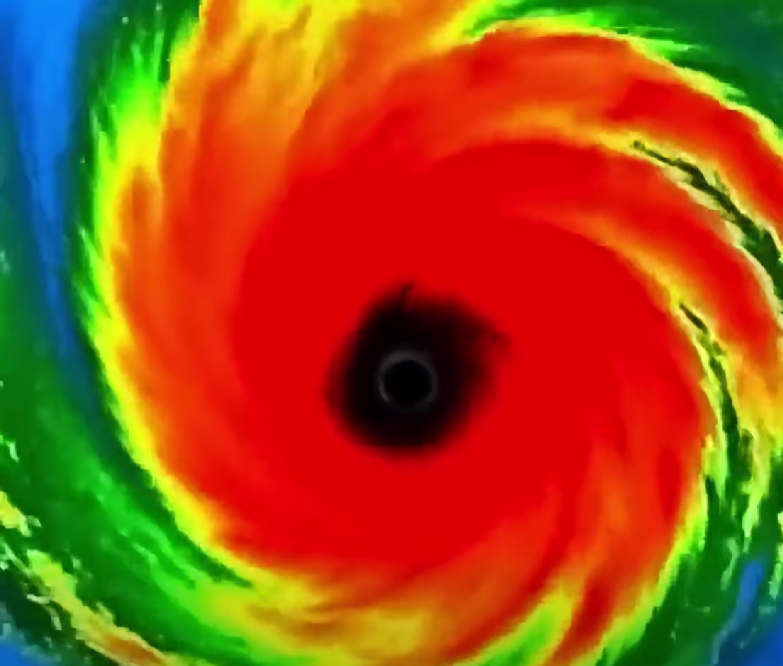
BREAKING NEWS: The National Hurricane Center (NHC) has begun posting advisories on Potential Tropical Cyclone Nine, which will likely become Tropical Storm Helene later today or tonight.
Big Picture: Tropical Storm Helene will likely form in the NW
Caribbean later today or tonight, then strengthen to a hurricane as it approaches an area from the Florida Panhandle through West Central Florida on Thursday. Helene could intensify to a category 2 or 3 hurricane that will likely produce a large wind field, and inflict wind, storm surge and rainfall impacts to a broad area of
Florida, Georgia and South Carolina.
In Detail:
1. The National Hurricane Center (NHC) forecasts an area of disorganized thunderstorms to become better organized and form a center of circulation in the
NW Caribbean Sea later today or tonight. The storm would likely be named Helene, and is forecast to track through the Yucatan Channel, then become a hurricane in the Gulf of Mexico.
Forecasters are closely monitoring a rapidly developing weather system in the northwestern Caribbean Sea that is expected to become Tropical Storm Helene later today or tonight, with the potential to strengthen into a significant hurricane before reaching Florida later this week.
The National Hurricane Center (NHC) has officially begun issuing advisories on Potential Tropical Cyclone Nine, signaling growing confidence that the disturbance will soon organize into a named storm. Meteorologists warn that once Helene forms, environmental conditions appear favorable for rapid strengthening as it moves northward toward the Gulf of Mexico.
The latest forecasts suggest Helene could intensify into a Category 2 or even Category 3 hurricane before making its closest approach to Florida on Thursday. If those projections hold, millions of people across Florida, Georgia, and South Carolina could face dangerous conditions including damaging winds, life-threatening storm surge, and significant flooding rainfall.
The developing system currently consists of a broad area of thunderstorms over the northwestern Caribbean. While it remains somewhat disorganized, forecasters say the storm is expected to become better structured as a center of circulation develops. Once that occurs, the system will likely receive the name Helene and begin strengthening more rapidly.
According to current forecast models, Helene is expected to move through the Yucatan Channel before entering the Gulf of Mexico, where warm ocean waters could provide the fuel needed for further intensification. Hurricanes often strengthen over exceptionally warm Gulf waters, and meteorologists are watching closely to see how quickly Helene develops once it reaches the region.
Areas along Florida’s Gulf Coast are already being urged to pay close attention to official forecasts and updates. While it remains too early to determine the exact location of any future landfall, experts stress that impacts could extend far from the center of the storm due to its potentially large wind field.
Unlike smaller tropical systems that concentrate their impacts near the eye, larger hurricanes can spread dangerous weather across hundreds of miles. This means communities far from the storm’s eventual center could still experience strong winds, flooding rains, and coastal flooding.
Storm surge is emerging as one of the primary concerns. As powerful winds push seawater inland, coastal communities can experience rapid flooding that threatens homes, businesses, and infrastructure. Emergency officials often describe storm surge as one of the deadliest hazards associated with hurricanes because it can occur quickly and with little room for error.
Heavy rainfall also remains a major threat. Forecasters warn that tropical systems of this size can produce widespread flooding, especially in low-lying areas and locations that have already experienced significant rainfall in recent weeks. Urban areas may face flash flooding as drainage systems become overwhelmed by intense downpours.
Residents across the southeastern United States are being encouraged to review emergency plans, check supplies, and remain informed as forecasts continue to evolve. Hurricane season is known for rapid changes in storm intensity and track, making it essential for people in potentially affected areas to stay alert.
Social media has already become flooded with discussions about the storm as weather enthusiasts and concerned residents share forecast graphics and tracking updates. Many are comparing the developing system to previous Gulf hurricanes that strengthened significantly before approaching the United States.
Meteorologists caution against focusing solely on the exact forecast track. Small shifts in a storm’s path can dramatically change where the worst conditions occur. Instead, experts recommend paying attention to the broader impact zone and preparing for the possibility of hazardous weather even if the center remains offshore.
The coming days will be critical in determining just how strong Helene becomes and which communities face the greatest risk. Forecast confidence continues to increase that the system will become a tropical storm soon, but questions remain regarding the speed and extent of its strengthening once it enters the Gulf of Mexico.
For now, officials are urging residents throughout Florida, Georgia, and South Carolina to monitor updates closely as the developing storm continues its journey northward.
With warm waters ahead and favorable atmospheric conditions in place, all eyes are now on Potential Tropical Cyclone Nine as it appears increasingly likely to become Hurricane Helene in the days ahead.


Leave a Reply